Hiking : Sägerei im Sefinental
Switzerland Bern Interlaken-Oberhasli administrative district
&fill=rgba(0,0,0,0))
Durée
Distance
Dénivelé
This hiking route takes you through the stunning area around Sägerei im Sefinental. With a total distance of 6.741 kilometers and an elevation gain of 889 meters, this hike is rated as difficult and is estimated to take around 3 hours and 46 minutes to complete.
As you start your journey, you will come across various points of interest along the trail. At the beginning of the hike, you will find a shelter to rest and enjoy the surrounding nature. Further along the trail, you will pass by a parking area where you can leave your vehicle before starting the hike.
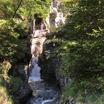
Midway through the hike, at around 0.57 kilometers from the start, you will encounter the picturesque Sefinenfall waterfall. This will be a great spot to take a break and immerse yourself in the beauty of the area.
As you continue on, you will also find a restaurant, Hotel Restaurant Stechelberg, where you can refuel and take in the breathtaking views.
Throughout the trail, you will also come across several information points, benches for resting, and drinking water spots to keep you hydrated.
Before embarking on this challenging hike, make sure to bring plenty of water, wear appropriate hiking gear, and check the weather forecast to ensure a safe and enjoyable experience. Enjoy the beauty of Sägerei im Sefinental and have a memorable hiking adventure!


