&fill=rgba(0,0,0,0))
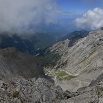
Σκολιό


This hiking route takes you through the breathtaking scenery of Mount Olympus, known as the home of the Greek gods. The trail is extremely difficult, covering a distance of 16.58 kilometers with an elevation gain of 1961 meters. It is recommended for experienced hikers due to its length and challenging terrain.
As you start your journey, you will come across Prionia, a restaurant located at the beginning of the trail where you can grab some refreshments before you begin. Along the way, there are several drinking water stations to keep you hydrated, as well as benches for resting and enjoying the stunning views.
Midway through the hike, you will reach the peak of Skolio, offering panoramic views of the surrounding mountains and valleys. This is a great spot to take a break and appreciate the beauty of the natural landscape. Further along the trail, you will pass by the Kαταφύγιο Α' "Σπήλιος Αγαπητός" alpine hut, where you can rest and refuel before continuing on.
At the end of the trail, you will reach the peak of Skala, where you can marvel at the stunning vistas before making your way back. Along the way back, you can stop by the waterfalls viewpoint for a final glimpse of the natural beauty of Mount Olympus.
It is important to bring plenty of water, snacks, and proper hiking gear for this challenging trek. Make sure to check the weather forecast before embarking on your journey and always follow safety precautions while hiking in the mountains. Enjoy the incredible views and unforgettable experience of hiking to the peak of Mount Olympus.


