Risco de las Bellotas - GR 10 (new)




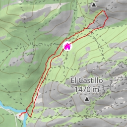
This hiking route takes you on a circular adventure through the beautiful Risco de las Bellotas area, following the GR 10 trail. With a total distance of 5.021 kilometers and an elevation gain of 474 meters, this moderate difficulty hike will offer stunning views and a variety of points of interest along the way.
Starting from the trailhead, you'll come across Cantocochino, a parking area where you can leave your vehicle before beginning your trek. As you venture further, you'll pass by Casa Torrero and Mesón del Montañero, two restaurants where you can refuel and grab a bite to eat.
About 2.3 kilometers into the hike, you'll reach Risco de las Lagunillas, a peak that offers panoramic views of the surrounding landscape. Continuing on, you'll encounter various other peaks such as Peña Sirio, Las Pilas, and El Castillo, each offering unique perspectives of the area.
Along the way, you'll also find shelters like the ones at Las Pilas and various informational points to learn more about the natural features around you. Be sure to stop by the picnic site at Canto Cochino for a peaceful break amidst nature.
As you near the end of the trail, you'll pass by Cancho de los Brezos, a rock formation worth exploring before completing your journey. This circular route provides a diverse mix of terrain and sights, making it a rewarding experience for hikers of all levels.
Before embarking on this hike, make sure to bring plenty of water, wear sturdy hiking shoes, and check the weather forecast to ensure a safe and enjoyable outing. Whether you're a seasoned hiker or just starting out, the Risco de las Bellotas - GR 10 trail is sure to impress with its natural beauty and diverse attractions.