&fill=rgba(0,0,0,0))
Wasserstein
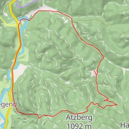
This hiking route takes you through the beautiful area of Wasserstein, offering a moderate challenge with a distance of approximately 5.4 kilometers and an elevation gain of 234 meters. It is estimated to take around 1 hour and 50 minutes to complete.
As you start your journey, you will come across various points of interest along the trail. At the beginning of the hike, you will find a drinking water source called "Armbad" and an information point about the area. Further along, there are benches and attractions like "Im Thier" and "Hexenkreis" for you to stop and appreciate the surroundings.
Midway through the route, you will discover a picnic site and another drinking water spot named "zum belebten Kaiserwasser." Additionally, there are facilities like shelter areas and benches for resting and enjoying the scenic views.
Towards the end of the hike, you will encounter points of interest such as the "Wasserstein" peak and cave entrances, providing a unique experience for nature enthusiasts. Nearby, there are more benches and picnic sites for you to relax before completing your circular journey.
It is advisable to bring an adequate amount of water, wear appropriate hiking gear, and check the weather forecast before embarking on this adventure. Whether you are a beginner or experienced hiker, this route offers a fantastic outdoor experience with a mix of natural beauty and historic points of interest.