&fill=rgba(0,0,0,0))
Pont du Clo..............


This hiking route takes you through a beautiful area with stunning natural features and convenient amenities along the way. The trail covers a distance of 2.534 kilometers with an elevation gain of 212 meters, making it an easy hike suitable for all skill levels.
Starting at the trailhead, you will first come across the Chalet du Lignon, a cozy restaurant where you can grab a bite to eat before or after your hike. Just a short distance away, there is an information point providing insights about the area. As you continue on, you will pass by parking areas where you can leave your vehicle.
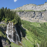
About midway through the hike, you'll reach the Pleureuse et Sauffaz viewpoint, offering breathtaking views of the surrounding landscape. Nearby, you can visit the Résurgence spring and the Cascade de la Sauffaz waterfall. These natural attractions provide a serene setting to rest and take in the beauty of the area.
Further along the trail, you will encounter a wayside cross and benches where you can pause for a moment of relaxation. As you near the end of the hike, you'll find the Cascade de la Pleureuse waterfall and the Pont de Bettere bridge.
Throughout the hike, there are information points scattered along the trail to help you learn more about the history and nature of the area. It is recommended to bring plenty of water, wear sturdy hiking shoes, and check the weather forecast before embarking on this adventure.
Overall, this out-and-back hiking route to Pont du Clo offers a delightful experience for nature lovers and hikers of all levels. Enjoy the scenic views and tranquil surroundings as you explore this picturesque trail.


