&fill=rgba(0,0,0,0))
Monte Pancherot
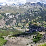
This hiking route takes you to Monte Pancherot, a challenging but rewarding trek in the beautiful region. The trail spans approximately 7.77 kilometers with an elevation gain of 371 meters, making it a difficult but achievable hike.
At the beginning of the trail, you will find the Rifugio Jean Barmasse, an alpine hut where you can rest and enjoy the stunning surroundings. As you continue, you will come across the Finestra Di Cignana, offering breathtaking views from a saddle point. Make sure to stop by the Belvedere Lago di Cignana viewpoint, located 2.65 kilometers from the start, for a panoramic vista of the area.
Throughout the hike, you will encounter several drinking water stations to refill your supplies and a shelter, Bivacco Forestale, for a quick break. The trail also features informational points with interesting facts about the region, perfect for learning more about the area as you trek along.
As you near the end of the route, you will reach the peak of Monte Pancherot, where you can revel in the sense of accomplishment and enjoy the stunning views surrounding you. Remember to bring plenty of water, wear appropriate hiking gear, and check the weather forecast before embarking on this adventure.
Overall, this out-and-back hiking route to Monte Pancherot offers a challenging yet rewarding experience for outdoor enthusiasts looking to explore the beauty of the region.
Other routes nearby


