&fill=rgba(0,0,0,0))
Бзерпи
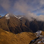
This hiking route takes you to the breathtaking area of Bzerpi, offering stunning views and natural beauty. With a total distance of 11.976 kilometers and an elevation gain of 799 meters, this hike is considered difficult and is estimated to take about 4 hours and 46 minutes to complete.
As you start your journey, you will come across several points of interest along the trail. About 4.46 kilometers from the start, you will find a water feature followed by more water sources at 4.51 and 4.59 kilometers respectively. There are also peaks to admire along the way, with one located just 0.09 kilometers from the trail and another at 5.99 kilometers. Take in the views from the various viewpoints, with one at 0.02 kilometers and another at 0.08 kilometers from the start.
For those in need of facilities, there are benches situated at 2.15 and 2.1 kilometers from the trailhead. If you require any information during your hike, there are information points at 0.1 and 0.57 kilometers from the start.
It is recommended to bring an ample water supply, snacks, and to check the weather forecast before embarking on this challenging journey. The route is an out-and-back type, meaning you will retrace your steps to return to the starting point. Enjoy the peaceful surroundings and the natural wonders that Bzerpi has to offer.


