&fill=rgba(0,0,0,0))
набережная Панорама - набережная Панорама


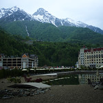
This hiking route takes you through a beautiful area with stunning views and convenient amenities along the way. The trail is considered super easy, making it perfect for hikers of all levels.
As you start your hike, you'll come across various points of interest. At the beginning of the trail, you'll find "Парковка P1," a parking area. Continuing on, you'll pass by "Пляж \"Роза Хутор\"" beach and a water feature.
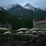
As you make your way further, you'll encounter "Мзымта Двор," a cafe with delicious refreshments. There are also several restaurants and fast-food options conveniently located along the trail for a quick bite to eat.
For nature enthusiasts, there are benches scattered throughout the trail where you can take a break and soak in the surroundings. There are also information points and viewpoints along the way for added interest.
It's always a good idea to bring water, snacks, and to check the weather forecast before embarking on this 1.564-kilometer circular hike. Enjoy the stunning views and the convenience of amenities along the way as you explore this beautiful area.


