&fill=rgba(0,0,0,0))
Hinterer Signalkogel
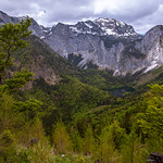
This hiking route takes you through the beautiful area of Hinterer Signalkogel. The trail is 3.944 kilometers long with an elevation gain of 315 meters, making it a moderate difficulty hike. It is estimated to take around 1 hour and 42 minutes to complete.
As you start your hike, you will come across a parking area right at the beginning of the trail. Make sure to bring enough water for the journey, as the first water source is located 0.26 kilometers into the hike. You will also pass by the Gasthaus Großalm restaurant and a wayside shrine at 0.21 kilometers.
Midway through the trail at 1.4 kilometers, you will reach a saddle called Lueg with stunning views of the surrounding area. Further along the path, at 1.97 kilometers, you will find the Hinterer Signalkogel viewpoint, where you can take in the picturesque scenery.
Remember to check the weather forecast before setting out on this hike and wear appropriate footwear. Enjoy the natural beauty and serenity of Hinterer Signalkogel on this out-and-back trail adventure.


