&fill=rgba(0,0,0,0))
Jay Peak
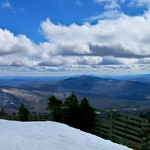


This hiking route will take you to the stunning Jay Peak area. The trail starts at the Route 242 trailhead parking area. From there, you will embark on a 4.927-kilometer out-and-back journey with an elevation gain of 457 meters, offering a moderate level of difficulty.
Along the way, you will pass by some notable points of interest. About 2.46 kilometers from the start, you will come across Sky Haus Deli, a great spot to grab a bite to eat. As you continue on, you will reach Jay Peak, a prominent peak in the area, located about 2.46 kilometers from the trail start. Additionally, there is a saddle located right on the trail, providing a scenic resting spot about 87 meters away from the trailhead.
Before embarking on this hike, make sure to bring an ample water supply, as well as check the weather forecast to ensure a safe and enjoyable experience. Enjoy the breathtaking views and natural beauty that Jay Peak has to offer on this invigorating outdoor adventure.


