&fill=rgba(0,0,0,0))
Bloseberg


This hiking route takes you through the picturesque area around Bloseberg. The trail is 4.089 kilometers long with an elevation gain of 115 meters, making it an easy hike suitable for all skill levels. The estimated duration for the hike is 1 hour and 14 minutes, but may vary based on individual pace.
As you start your journey, you will come across a convenient parking area, just 5 meters away from the trailhead. This is a great spot to leave your vehicle before embarking on the hike. About 1.24 kilometers into the hike, you will encounter an information point named "Waldi". This is a perfect place to learn more about the area and its surroundings.
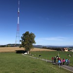
Midway through the hike, at 2.04 kilometers, you will reach the peak of Bloseberg, offering stunning panoramic views of the surrounding landscape. Take some time to appreciate the beauty of nature from this vantage point. Nearby, at the same distance, you will find another information point called "Grüt", providing additional insights into the area.
Additionally, at 2.04 kilometers, you will discover a viewpoint named "Blosenberg". This spot offers another perspective of the scenery and is a great place to take a rest and capture some memorable photos.
Before setting out on this adventure, ensure you bring an adequate supply of water, wear appropriate footwear, and check the weather forecast. Enjoy your hike to Bloseberg and immerse yourself in the natural beauty of the surroundings.


