&fill=rgba(0,0,0,0))
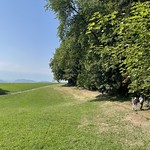
Bauplatz


This hiking route is located in a picturesque area with stunning views and various points of interest along the way. The trail is an out-and-back type, with a total distance of 2.329 kilometers and an elevation gain of 123 meters, making it relatively easy in terms of difficulty and suitable for hikers of all levels.
As you embark on this adventure, you will come across several points of interest. At the beginning of the trail, you will find a parking area where you can leave your vehicle before starting your hike. Shortly after that, just 0.02 kilometers from the start, Möschberg restaurant awaits, offering a place to rest and refuel before continuing your journey.
As you make your way along the trail, at around 1.14 kilometers from the start, you will reach Bauplatz, a lovely picnic site where you can take a break and enjoy a meal surrounded by nature. Further along, at 1.06 kilometers from the start, there is a drinking water station, providing a convenient spot to refill your water bottle and stay hydrated.
For those seeking a viewpoint to admire the surrounding landscape, Bauplatz offers breathtaking views at 1.16 kilometers from the start. Additionally, along the route, you will find information points and benches scattered throughout, offering opportunities to learn more about the area and take a moment to rest.
It is recommended to bring an adequate supply of water, as well as snacks and sturdy hiking shoes. Checking the weather forecast before heading out is also advisable to ensure a safe and enjoyable hiking experience. With its scenic views and interesting points of interest, this hiking route promises a memorable outdoor adventure for nature enthusiasts and hikers alike.


