&fill=rgba(0,0,0,0))
Gasterngesicht


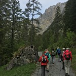
This hiking route offers a 10.419 kilometers adventure with an elevation gain of 202 meters, taking an estimated time of 2 hours and 55 minutes to complete. The trail is classified as difficult due to its length and elevation gain.
Starting at the parking area, you will find yourself surrounded by the beauty of nature as you embark on this circular route. Just 10 meters from the trail, you will come across a water source, perfect for refilling your water bottle at the beginning of your journey.
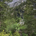
As you continue on, about 230 meters from the start, you will encounter another water feature slightly off the trail. This marks the start of your ascent. At 530 meters from the beginning, there is another water source, so be sure to stay hydrated throughout your hike.
Nearly 1 kilometer in, you will find a bench where you can take a break and soak in the surroundings. Around 1.7 kilometers from the start, you will pass by another water spot, followed by another at 2.63 kilometers.
The highlight of this hike is the Gasterngesicht viewpoint, located 5.2 kilometers into the journey. From here, you can enjoy a breathtaking panoramic view of the area.
Towards the end of the route, at around 4.99 kilometers, you will come across the Pletschenweidli information point, providing insight into the area's flora and fauna.
Remember to bring an ample water supply, wear appropriate hiking gear, and check the weather forecast before setting out on this challenging yet rewarding hike. Explore the wonders of the Gasterngesicht area on this picturesque trail.


