&fill=rgba(0,0,0,0))
Cuel Maior


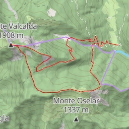
This hiking route takes you through the picturesque area surrounding Cuel Maior. With a total distance of 8.379 kilometers and an elevation gain of 227 meters, this difficult trail is sure to provide a challenging yet rewarding experience.
As you begin your journey, you will come across a parking area conveniently located at the start of the trail. This is the perfect spot to leave your vehicle before setting off on your adventure. Just a short distance from the parking area, you will find a shelter where you can take a break and enjoy some rest.
Continuing along the trail, you will reach Cuel Maior, a stunning peak that offers breathtaking views of the surrounding landscape. This is a great spot to take in the beauty of the area and snap some photos to remember your hike.
Along the way, you will also come across a picnic site where you can stop for a meal or snack. Additionally, there are information points scattered throughout the trail, providing interesting facts and details about the area.
If you find yourself in need of refreshment, there is a drinking water station located midway through the hike. Be sure to stay hydrated and bring plenty of water with you to keep energized throughout the journey.
Before embarking on this hike, be sure to check the weather forecast and pack accordingly. It's recommended to wear sturdy hiking shoes, bring a map or GPS device, and let someone know your plans before heading out.
Overall, this circular hiking route offers a challenging yet exhilarating adventure through the stunning landscape of Cuel Maior. Enjoy the natural beauty, take your time to explore the area, and make memories that will last a lifetime.