⛷️ Ski Touring App: How to Use Relief Maps for Your Winter Outings?
Ski Touring • Mountain • Tech
If you are looking for the ultimate tool to visualize your next lines and organize your winter adventures, let us introduce you to Relief Maps. Designed by enthusiasts for enthusiasts, it transforms your smartphone into a true mountain cockpit. In this article, we explain how Relief Maps will become your best ally for planning and securing your ski touring outings.
Ski touring is about freedom, but it is also a discipline that leaves nothing to chance: weather, snow science, terrain... With Relief Maps, you have all the keys in hand (and in 3D!) to head out with peace of mind. Follow the guide!
Going Ski Touring: Why Relief Maps Changes the Game

Having the legs is good, but knowing exactly where you are putting your skis is better. Relief Maps doesn't just show you a flat map; it allows you to understand the terrain before you even get there.
Whether you are a multi-day raid addict or a fan of the express lunch break outing, the app adapts to your practice. Here is why it has become essential in the digital backpack of the modern skier.
Essential Features for Your Powder Days ❄️
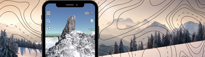
🗺️ The 3D Map: Total Immersion
This is the signature of Relief Maps. Forget contour lines that you have to decipher with a magnifying glass. Here, you explore the terrain in ultra-realistic 3D. You can visualize the valleys, spot rock bands, and anticipate key passages as if you were flying over the massif. for scouting, it is simply unbeatable.
🏔️ Slope and Aspect Maps
Safety first. Relief Maps integrates indispensable layers for the ski tourer:
- Slope Map: Identify risk zones (slopes greater than 30°) at a glance thanks to a precise color code.
- Aspect (Orientation) Map: Are you looking for spring snow on south faces or cold powder on north faces? The exposure tool helps you find the best snow of the moment.
⚠️ Avalanche Bulletins Available Across Europe
No need to juggle between 15 different websites if you cross the border. Whether you are in the French Alps, Switzerland, Italy, or elsewhere in Europe, Relief Maps centralizes the Avalanche Risk Estimation Bulletins. You have the crucial info, directly on the map, to make the right decisions in the morning over coffee.

📍 Skitour and Camp to Camp Routes
Lacking inspiration? Relief Maps aggregates the community wealth of Skitour and Camp to Camp (C2C). Access thousands of topos (guidebooks), read the latest trip reports, and download the associated GPS tracks. It's like having the knowledge of thousands of practitioners in your pocket.

📲 Intuitive Route Planning
Tracing your route has never been simpler. Place your points on the 3D map, and the app calculates the distance, positive and negative elevation gain, and estimated time for you. You can adjust your course to avoid a steep slope or aim for a summit, then export it in GPX or follow it live.

📵 Offline Maps
We know that up there, 4G doesn't always get through. With Relief Maps, you can download your maps (topographic, satellite, slope maps...) directly to your phone. Once in the field, even in airplane mode at the bottom of a lost valley, you have access to your precise mapping and your GPS position. Indispensable for never losing your way.
Why Choose Relief Maps for Your Season?
Unmatched Terrain Visualization Where other apps remain in 2D, Relief Maps offers immediate terrain reading. It is a major safety asset for validating an itinerary, especially in fog or on complex terrain.
All-in-One Planning, weather, European Avalanche Bulletins, community topos... You no longer need to open three different applications. Relief Maps is the Swiss Army knife of the connected mountaineer.
An Active Community By using Skitour and C2C topos, you benefit from a living database that is constantly updated by the community. You know if it goes, if the track is broken, or if you need to carry the skis.
Ready to Track Your First Line?
Relief Maps is more than just a GPS; it is a complete decision-making aid tool for everyone who loves the winter mountains. Whether you are preparing a traverse of the Alps or a Sunday outing, the application brings you the precision and safety you need.
👉 Download Relief Maps now and rediscover the mountain in 3D!