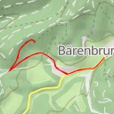
Hiking : Jungfernsprung
Deutschland Rheinland-Pfalz Südwestpfalz Dahn
&fill=rgba(0,0,0,0))
Durée
Distance
Dénivelé


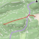
This hiking route will take you to the beautiful area of Jungfernsprung. The trail is an out-and-back type, starting at coordinates 7.772909, 49.154095 and leading to the destination at 7.773984, 49.153121.
The total distance of the hike is 13.17 kilometers, with an elevation gain of 91 meters. The estimated duration of the hike is around 2 hours and the trail is of moderate difficulty due to its length and elevation.
As you start your journey, you will come across various points of interest along the way. These include parking areas, a café named Café Zürn Bäckerei & Konditorei, a restaurant called Café Eisheisel, viewpoints like Jungfernsprung, shelters, fountains, information points, artwork, historic wayside crosses, and benches for resting.
It is important to bring an ample supply of water, wear appropriate hiking shoes, and check the weather forecast before heading out on the trail. Make sure to take breaks as needed and enjoy the stunning natural surroundings of Jungfernsprung during your hike.