&fill=rgba(0,0,0,0))
Kuźnice

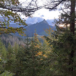


Welcome to the hiking route in Kuźnice! This scenic trail offers a wonderful opportunity to explore the natural beauty and historical sites of the area. With a total distance of 2.721 kilometers and an elevation gain of 196 meters, this hike is rated as easy, suitable for all skill levels.
Starting off the trail, you will first come across the picturesque Stara Karczma, a historic building dating back decades, located just 0.02 kilometers from the beginning. As you continue, at 0.05 kilometers from the start, you'll find the ruins of Fundamenty dworu, offering a glimpse into the area's rich history.
Midway through the hike, at 1.22 kilometers from the start, you will reach the peak of Boczań, a natural viewpoint that provides stunning panoramic views of the surroundings. This is a perfect spot to take a break and appreciate the beauty of the landscape.
Along the trail, you will also pass by amenities such as drinking water stations, restaurants like Yurtabar and Zajazd Górski Kuźnice, and information points providing insights into the region's attractions.
Remember to bring plenty of water, especially on hot days, and check the weather forecast before embarking on your hike. Whether you're a history enthusiast, a nature lover, or simply seeking a peaceful outdoor adventure, this hiking route in Kuźnice offers a delightful experience for all. Enjoy your hike!


