&fill=rgba(0,0,0,0))
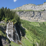
Cascade de la Sauffaz


Welcome to the hiking route to Cascade de la Sauffaz!
Located in a picturesque area, this trail offers a 2.587-kilometer round trip with an elevation gain of 212 meters, making it an easy hike suitable for all skill levels.
Starting at Chalet du Lignon, you'll begin your journey with stunning views right from the beginning. As you make your way along the trail, you'll pass by interesting points of interest such as Pleureuse et Sauffaz, a historical site. Along the way, you'll also come across benches and information points where you can learn more about the area.
One of the highlights of the hike is the Cascade de la Sauffaz, a beautiful waterfall located approximately 1.29 kilometers from the trailhead. This majestic waterfall is a perfect spot to take a break and enjoy the natural beauty of the surroundings.
Before embarking on this hike, make sure to bring plenty of water, as well as check the weather forecast to ensure a safe and enjoyable experience. Whether you're a seasoned hiker or just starting out, this hike offers something for everyone to enjoy. So lace up your hiking boots and get ready to explore the stunning Cascade de la Sauffaz!


