Hiking : Drachenfels
Deutschland Rheinland-Pfalz Südwestpfalz Busenberg
&fill=rgba(0,0,0,0))
Durée
Distance
Dénivelé


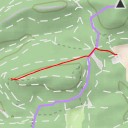
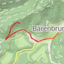
This hiking route takes you through the beautiful area surrounding the Drachenfels in Germany. The trail is an out-and-back type, starting at coordinates 7.831374, 49.121326 and leading to the destination at coordinates 7.828833, 49.12207. The total distance of the route is 6.19 kilometers, with an elevation gain of 33 meters.
As you begin your hike, you'll pass by the historic Burgruine Drachenfels, a castle located right at the start of the trail. Be sure to explore this ancient site before continuing on. Further along the route, you'll come across the Drachenfels viewpoint, offering stunning views of the surrounding natural landscape from its peak. This is a great spot to take a break and capture some scenic photos.
Throughout the hike, you'll encounter several points of interest, such as the Drachenfelshütte restaurant and the Schulerturm climbing area. These locations provide opportunities to rest, refuel, and enjoy the unique features of the area.
The trail is of moderate difficulty due to its length and slight elevation gain, so be prepared with proper hiking gear and plenty of water. It's also recommended to check the weather forecast before embarking on this adventure.
Overall, this hiking route to the Drachenfels offers a mix of historical sites, natural beauty, and recreational opportunities for hikers of various skill levels. Enjoy the journey and take in the breathtaking views along the way!