Hiking : Birkenblick
Deutschland Rheinland-Pfalz Südwestpfalz Hinterweidenthal
&fill=rgba(0,0,0,0))
Durée
Distance
Dénivelé
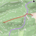
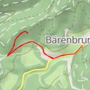
This hiking route takes you through the beautiful area surrounding Birkenblick. The trail starts at an elevation of 221 meters at Restaurant Dionysos, where you can grab a meal before beginning your adventure. As you make your way through the trail, you'll come across various points of interest such as Cafe Zürn, Kleiner Mühlenberg peak, and the memorial for Förster J. Gethmann.
At around 1 kilometer into the hike, you'll reach the Birkenblick viewpoint, where you can enjoy stunning panoramic views of the surrounding landscape. Just a short distance away from the viewpoint is a picnic site, perfect for taking a break and soaking in the scenery.
The trail is an out-and-back route, totaling 2.365 kilometers in distance with an elevation gain of 98 meters. While the trail is relatively short, be prepared for some uphill sections due to the elevation gain. It is recommended to bring plenty of water, wear sturdy hiking shoes, and check the weather forecast before setting out.
Whether you're a hiking enthusiast or just looking for a leisurely stroll in nature, this hike to Birkenblick offers a delightful experience with opportunities to explore various points of interest along the way. Enjoy the serenity of the outdoors and make lasting memories on this picturesque trail.