Hiking : Honigfels-Massiv
Deutschland Rheinland-Pfalz Südwestpfalz Busenberg
&fill=rgba(0,0,0,0))
Durée
Distance
Dénivelé
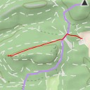
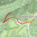
This hiking route takes you through the beautiful area surrounding the Honigfels-Massiv. The trail is a circular route, starting at a parking area near Gaststätte Bärenbrunnerhof. Make sure to check the weather forecast before you go and bring enough water for the hike.
As you start your journey, you'll pass by the Hofladen Bärenbrunnerhof farm shop where you can pick up some fresh local produce. Further along the trail, you'll come across the Bärenbrunnerhof information point, providing you with insights into the area's history and wildlife.
One of the highlights of the hike is the Honigfels-Massiv, a stunning rock formation perfect for climbing enthusiasts. As you continue on, you'll also encounter the Honigfels rock formation and enjoy panoramic views from the viewpoints along the route.
The trail covers a distance of 2.7 kilometers with an elevation gain of 104 meters, making it a moderate difficulty hike suitable for most hikers. Be sure to take your time and enjoy the scenery along the way.
At the end of the hike, you'll find yourself back at the parking area near Gaststätte Bärenbrunnerhof, where you can grab a well-deserved meal and rest after your adventure. Don't forget to explore the area's other attractions and take in the natural beauty that surrounds you.