Hiking : Kühhungerfelsen
Deutschland Rheinland-Pfalz Südwestpfalz Schwanheim
&fill=rgba(0,0,0,0))
Durée
Distance
Dénivelé
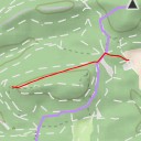
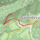
Welcome to the hiking route to Kühhungerfelsen! This trail takes you through the beautiful countryside, starting at Gaststätte Bärenbrunnerhof. This is a popular restaurant where you can grab a bite to eat before or after your hike. As you begin your journey, you'll pass by Honigfels-Massiv and Bärenbrunner Schandarie, popular climbing spots in the area.
Further along the trail, you'll come across Honigfels, another great spot for climbers. If you're looking for accommodation for the night, Bärenbrunner Hütte is just a short distance away. Don't forget to check out the stunning viewpoints at Kühhungerfelsen and enjoy the breathtaking scenery.
As you continue on the trail, you'll find various facilities such as parking areas, benches, and information points to guide you along the way. The route is an out-and-back type, so you'll return to the starting point at Gaststätte Bärenbrunnerhof.
The total distance of the hike is 27.87 kilometers with an elevation gain of 125 meters. This hike is of moderate difficulty due to its length and some climbing spots along the way. Be sure to bring plenty of water, snacks, and check the weather forecast before you head out.
Enjoy the tranquility of nature and the thrill of exploration on this hike to Kühhungerfelsen!