Hiking : Pfaffenfelsen
Deutschland Rheinland-Pfalz Südwestpfalz Dahn
&fill=rgba(0,0,0,0))
Durée
Distance
Dénivelé


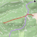
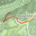
This hiking route will take you through the beautiful area near Pfaffenfelsen, starting at coordinates 7.772894, 49.147961. The destination of the hike is Pfaffenfelsen, located at coordinates 7.770807, 49.146092.
As you begin your hike, you can explore various points of interest along the way. You will pass by the Felsengraf restaurant, which is a good spot to grab a bite before or after your hike. There are also parking areas such as P2 - Hotel Felsenland, where you can leave your car before starting the trail.
During your hike, you will encounter points like Wachtfelsen viewpoint and Grillhütte shelter, where you can take a break and enjoy the scenic views. There are also climbing spots like Schwalbenfelsen and Rot-Graue Wand for more adventurous hikers.
The total distance of this hike is 8.47 kilometers with an elevation gain of 43 meters. The duration of the hike is approximately 2 hours. The trail is considered to be of moderate difficulty due to its length and elevation gain.
Don't forget to bring plenty of water, snacks, and sunscreen for your hike. It is also recommended to check the weather forecast before heading out to ensure a safe and enjoyable trek. Enjoy your hike to Pfaffenfelsen!