Hiking : Wasgaublick
Deutschland Rheinland-Pfalz Südwestpfalz Wilgartswiesen
&fill=rgba(0,0,0,0))
Durée
Distance
Dénivelé
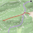
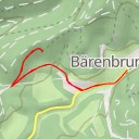
This hiking route will take you to the picturesque area of Naturpark Pfälzerwald in Germany. The trail starts at a parking area near the town of Wilgartswiesen. Make sure to bring enough water and snacks for the journey, as well as a good pair of hiking shoes.
As you begin your hike, you will come across a bench where you can take a short rest before continuing on the trail. Further along, you will find an information point that provides details about hiking in the region of Hauenstein.
As you make your way towards the Wasgaublick viewpoint, you will encounter a memorial known as Ritterstein Nr. 226 "Alte Straße Keltenzeit". This historical landmark adds a unique touch to the hike and offers a glimpse into the past.
The highlight of the route is the Wasgaublick viewpoint, where you can enjoy stunning panoramic views of the surrounding area. Take some time to relax and soak in the beauty of the landscape before heading back the way you came.
This out-and-back trail covers a distance of 6.02 kilometers with minimal elevation gain, making it suitable for hikers of all levels. Remember to check the weather forecast before setting out on your adventure to ensure a safe and enjoyable hike. Enjoy your trek to Wasgaublick!