&fill=rgba(0,0,0,0))
Blosenberg


Welcome to the hiking route to Blosenberg!
This trail is located in a beautiful area with stunning views and an easy difficulty level, making it perfect for hikers of all skill levels. The total distance of the route is 4.097 kilometers with an elevation gain of 115 meters, and it can be completed in approximately 1 hour and 14 minutes.
As you start your hike, you will come across a parking area nearby. This is a convenient spot to leave your vehicle and begin your adventure. About 1.24 kilometers into the hike, you will reach an information point called Waldi, where you can learn more about the area and its surroundings.
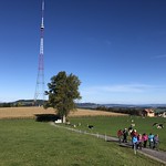
Continuing further along the trail, at approximately 2.05 kilometers from the start, you will encounter the peak of Bloseberg. This is a great spot to take a break and enjoy panoramic views of the surrounding landscapes.
On your way back, you will pass by another information point named Grüt, located right by the trail. About the same distance from the start as Bloseberg, you will find a viewpoint called Blosenberg, offering another opportunity to admire the scenic vistas.
Remember to bring plenty of water, wear appropriate hiking gear, and check the weather forecast before embarking on this journey. Whether you're a seasoned hiker or just starting out, this route to Blosenberg promises a memorable outdoor experience in a picturesque setting. Enjoy your hike!


