&fill=rgba(0,0,0,0))
Oberhauserknott


Located in the picturesque region of Oberhauserknott, this hiking route offers a pleasant and easy trek through the stunning natural surroundings. The trail spans a total distance of 2.852 kilometers with an elevation gain of 151 meters, making it suitable for hikers of all levels.
As you embark on your journey, you will come across several points of interest along the way. At the beginning of the trail, you will find a convenient parking area. As you continue onwards, you will encounter the Alpenrose restaurant, where you can stop for a delicious meal or refreshments.
Further along the path, you will reach the Lenkhof farm, offering a glimpse into local agricultural practices. For a scenic break, take a moment to rest at one of the benches conveniently placed along the trail.
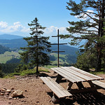
One of the highlights of the hike is the Knottnkino viewpoint, located midway through the route. This unique outdoor cinema provides a stunning panoramic view of the surrounding landscapes, perfect for capturing memorable photos.
For those seeking a bit of adventure, the Rotensteinkogel - Pietrarossa peak offers a challenging detour from the main trail. However, the true reward lies in reaching this high point and taking in the sweeping vistas.
As you near the end of your journey, you will find additional benches and drinking water stations to rest and rehydrate. Be sure to check the forecast before setting out and remember to bring plenty of water for the trek.
Overall, this out-and-back route to Oberhauserknott promises a delightful hiking experience with a mix of natural beauty, cultural highlights, and breathtaking viewpoints. Whether you're a seasoned hiker or just starting out, this trail offers something for everyone to enjoy.


